The Celestial Sphere. The sky can be thought of as the inside of a sphere of very large radius with us in the middle. The rotation of the Earth makes the celestial sphere appear to rotate every 23hr and 56min on an axis from the north celestial pole to the south celestial pole. These poles are the points on the celestial sphere where an extension of the Earth's rotational axis would intersect the celestial sphere.
Horizon coordinate system We can specify a a spot on the sky (direction in space) by giving its altitude (angle from horizon) and its azimuth (angle from north through east). The north celestial pole has an azimuth of 0 degrees and an altitude equal to the observers latitude (35 degrees for Norman). In this diagram, the observer is at 40 degrees latitude - DEnver or Philadelphia, for example.
Latitude and longitude on Earth. The surface of the Earth can be thought of as a 2 dimensional surface and any point can be specified with 2 coordinates- latitude and longitude. Latitude is the angle between a point and the the equator as seen from the center of the Earth. Longitude is the angle east west from the point to the meridian passing through Grenwich, England.
Meridian and celestial sphere. The zenith is the point directly overhead from your location. The meridian is a cicle passing from straight north, through the zenith, and on to straight south. As the Earth turns, objects (except those near the poles) appear to rise, reach maximum altitude as the pass the merdian (transit) and then set. The celestial equator is a great circle 90 degrees away from the celestial poles- it can also be thought of as an extension of the plane that coincides with the equator of the Earth.
(1) Star paths as seen from northern mid-latitudes (2) Another viewgraph of same idea From mid-northern latitudes, the celestial sphere can be divided into 3 regions. First, stars within a certain angle (equal to the observers latitude) of the north celestial pole are always above the horizon. We call these circumpolar stars. A mirror-image region around the southern celestial pole contains stars that are never seen by the observer. Stars between these two circumpolar caps rise and set as the Earth turns. We can only see the half of the celestial sphere above our horizon, of course (unlike the 8000 mile tall woman in the diagram who can see "around" the Earth!). The dashed lines are the (unseen to us) paths of stars below our horizon.
Star paths. Paths of stars in the sky as seen looking towards the north, east, and south as seen from mid-northern latitude. See the preceeding figure to help understand what the star paths look like.
Seasons. The Earth experiences seasons because of the tilt of the Earth's rotational axis by 23.5 degrees from the perpendicular to the plane of the Earth's orbit around the Sun.
Celestial Equator and Ecliptic. The ecliptic is the great circle on the celestial sphere that the Sun appears to follow as the Earth revolves around the Sun. The ecliptic is tilted by 23.5 degrees with respect to the celestial equator. The solstices mark the points where the Sun is farthest north or south of the equator, and the equinoxs mark the two points when the Sun is exactly on the equator.
Path of Sun in sky. As the Earth revolves around the Sun, it appears to us that the Sun moves in a great circle.
Constellations of the Zodiac. If you could see the stars in the daytime, the Sun would appear in different constellations as it moves around the ecliptic. We say the Sun is "in" the constellation it appears in front of.
Sun at soltices. At the time of summer solstice (around June 21 for us in northern hemisphere) the Sun is farthest north of the equator, sunlight is hitting us most directly, and the time the Sun is above the horizon is greatest. At winter solstice, the Sun is farthest south of the equator, Sunlight hits us at a large angle from the vertical, and the Sun is above the horizon the least amount of time possible. Note the lengths of the shadow of the figure. At local noon at the summer solstice (from Norman at latitude 35 degrees) you would have a short shadow extending to the north. At local noon at the winter solstice, your shadow would be much longer, as the Sun is much lower in the sky. Only if you in the Tropics (zone with latitude between -23.5 and +23.5 latitudes) can the sun ever be at the zenith.
Sun at different seasons This image shows the motion of the Sun across the sky on 3 different dates. The bottom curve of solar images are hourly images taken on 22 December, at the winter solstice. By counting the images, you can see that the Sun is above the horizon for about 8 hours. The middle line of images is taken at one of the equinoxes (spring or autumn). At these two times of the year, the sun is on the clestial equator (the ecliptic crosses the equator on the equinoxes) and so it is above the horizon for 12 hours and below the horizon for 12 hours. The top curve of images are for summer solstice (~22 June) when the Sun is at its most northern declination, so it appears above the horizon for the longest time (about 15 hours). The dates and times are for a mid-northern latitude. (Not sure the exact latitude of the phtograph site.)
Sun farthest from Earth in January These photos show the size of the Sun at perihelion (Earth closest to Sun) and aphelion (Sun farthest from Sun). The difference in distance (and apparent size of Sun) is about 3%. Note that the SUN LOOKS LARGEST AND IS HENCE CLOSEST TO EARTH IN JANUARY, when it is WINTER (at least in the northern hemsiphere). So, clearly, the earth-Sun distance plays NO ROLE in the seasons, as some people think.
Annotated sky calendar. Astronomers use calendars such as this to see what is going on each night. As the times for sky phenomena (sunset, LST at local midnite, etc) depend on the observers position on the earth, a calendar such as this must be custom computed for each earth position.
Example of a star atlas This is a page from a simple star atlas. (There are many different ones, at different levels of detail.) Note the coordiate system: the "y axis" is measured in degrees declination (DEC) north or south of the celestial equator; the "x axis" is measured in units of hours, minutes and seconds of right ascension (RA). The zero point of the RA scale is set where the ecliptic (dashed line) crosses the equator in the fall (the autumnal equinox). This chart contains the point where the ecliptic crosses the equation at RA = 0, DEC = 0. The angle between equator and ecliptic is 23.5 degrees, as shown.
Any point on the celestial sphere can be specified by giving its RA and DEC, just like any point on the earth can be specified with its latitude and longitude. For example, the exact coordiantes of M31, a nearby galaxy shown on the chart, are: RA = 0 hr 42 min 44.32 sec ; DEC = 41 deg 16 arcmin 8.5 arcsec.
As the Earth turns, the RA on the merdian continuously changes. The RA on the meridan at any instant is the Local Sideral Time (LST). The LST at midnite (wall clock time) for each night at a particular place can be found on the sky calendar (column 3).
Sky&Tel grapical almanac Sky and Telescope magazine (you all have subscriptions, right?) publishes the "Skygazer's Almanac", a nice graphical almanac that shows what is happening in the sky each year, particularly when the planets are visible.
Effects of precession. The Earth's rotational axis precesses, much like a spinning top. The precessional period is about 26,000 years. Because of precession, the celestial poles and equator move around the celestial sphere. At present (left hand diagram) the star Polaris in close to the north celestial pole, and is called the North Star. In 13,000 years (right hand diagram) the pole will be located near the star Vega. Of course, its not the stars that have moved, but the Earth that has "wobbled"!
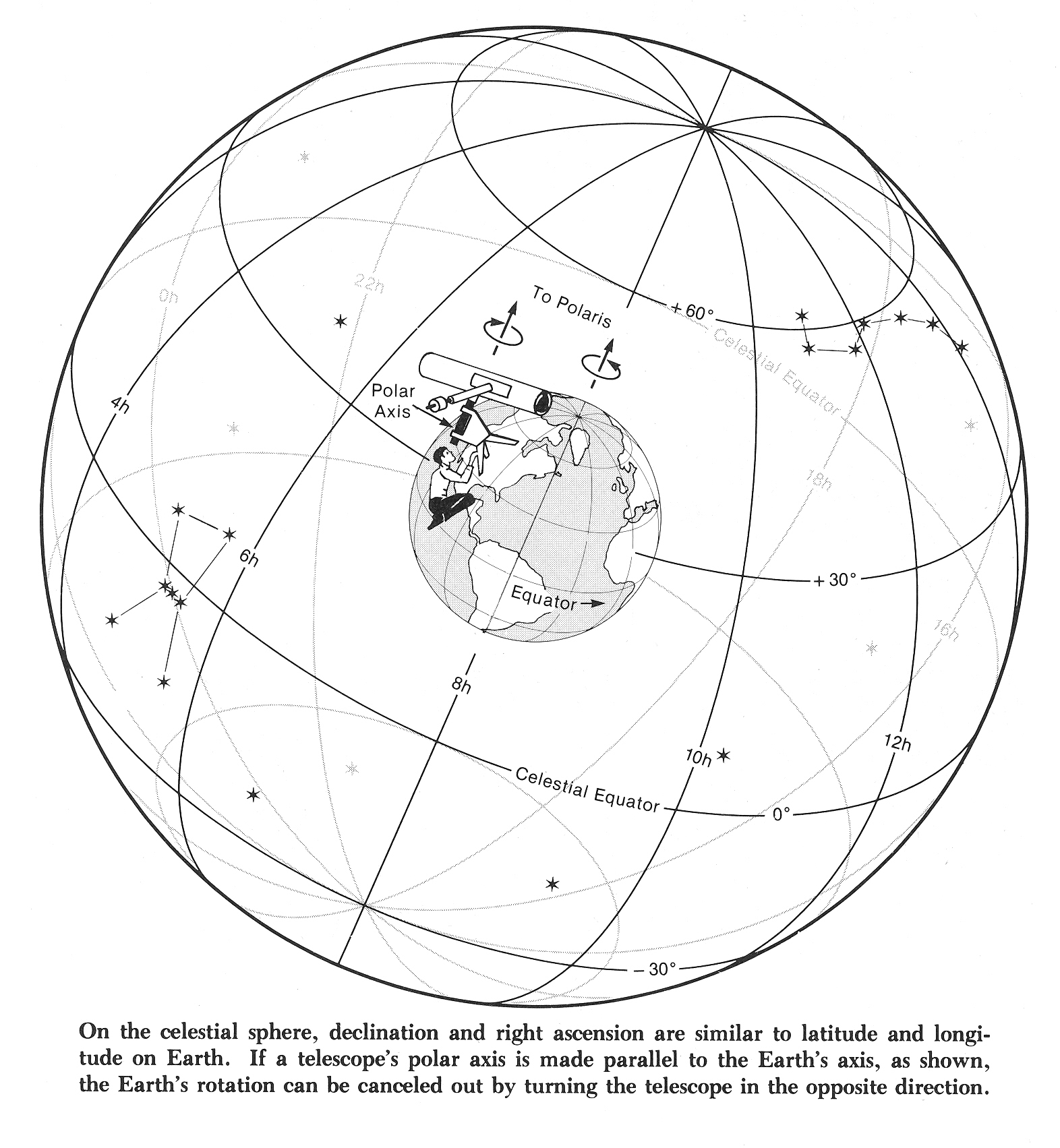
(1) Celestial sphere _(2) RA and DEC Two diagrams that will help visualize celestial coordinate system.
(1) Big Dipper angles _(2) Hand angles References useful in estimating angles on the sky. People's hands have different sizes, of course, but the ratio of hand size to arm length (which is all that matters for measuring an angle) is more constant than size alone. These angles are with arm fully extended.